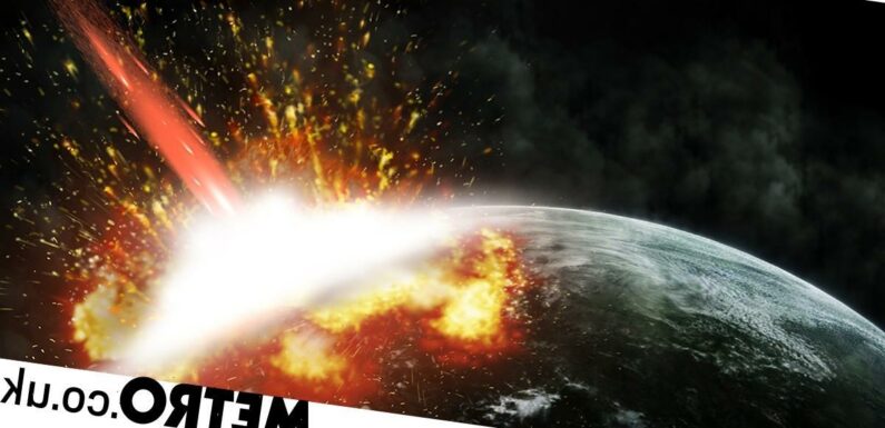

The asteroid impact that wiped out the dinosaurs was so devastating it triggered waves 30,000 times more powerful than the 2004 Indian Ocean tsunami.
New research has revealed swells reaching up to a mile high swept the planet – drowning everything in their path.
These devastating waves scoured the seabead for thousands of miles stretching from the site of the impact all the way round to New Zealand – 7,500 miles away.
Lead author Molly Range, of the University of Michigan, said: ‘This tsunami was strong enough to disturb and erode sediments in ocean basins halfway around the globe, leaving either a gap in the sedimentary records or a jumble of older sediments.’
The finding is based on computer simulations and a review of geological records at more than 100 sites worldwide.
Three quarters of species disappeared after a city sized space rock smashed into the Yucatan peninsula in the Gulf of Mexico 66 million years ago.

They included all non-avian dinosaurs, pterosaurs, ammonites and most marine reptiles.
Initial energy was up to 30,000 times greater than the Boxing Day tsunami which killed more than 230,000 people – one of the largest in modern times.
It gorged out a crater more than 60 miles wide, known as Chicxulub. In minutes, everything within hundreds of miles was incinerated.
Ten minutes after the projectile hit, and 137 miles from the point of impact, a mile high tsunami ring shaped wave began sweeping across the ocean in all directions.
Temperatures dropped, acid rain fell and the sun was blocked out for months – also killing off 90 percent of plants.
The US team focused on marine sediments deposited just before or after the impact 66 million years ago, and the subsequent ‘K-Pg boundary’, which closed the Cretaceous.
Ms Range, a student who carried out the study for a master’s thesis, said: ‘The distribution of the erosion and hiatuses we observed in the uppermost Cretaceous marine sediments are consistent with our model results, which gives us more confidence in the model predictions.’
Her model showed the tsunami radiated mainly to the east and northeast into the North Atlantic Ocean, and to the southwest.
It travelled through the Central American Seaway, which used to separate North and South America, into the South Pacific.
In those basins and in some adjacent areas, underwater current speeds likely reached almost half a mile an hour – enough to erode fine-grained sediments on the seafloor.
The South Atlantic, the North Pacific, the Indian Ocean and the region that is today the Mediterranean were largely shielded from the strongest effects.
Most samples analysed came from cores collected during scientific ocean-drilling expeditions.
Co author Professor Brian Arbic, who oversaw the project, said: ‘We found corroboration in the geological record for the predicted areas of maximal impact in the open ocean. The geological evidence definitely strengthens the paper.’
Of special significance are outcrops of the K-Pg boundary on the eastern shores of New Zealand’s north and south islands – more than 7,500 miles from ‘ground zero.’
The heavily disturbed and incomplete sediments, called olistostromal deposits, were originally thought to be the result of local tectonic activity.
But their age and location directly in the modelled pathway of the tsunami points to a different origin.
Ms Range said: ‘We feel these deposits are recording the effects of the impact tsunami, and this is perhaps the most telling confirmation of the global significance of this event.’
Her program tracked the chaotic first ten minutes of the event – from the impact, to formation of the crater and initiation of the tsunami.
Based on findings of previous studies, the researchers’ asteroid was 8.7 miles in diameter and moving at 27,000 mph.
It struck a granite crust overlain by thick sediments and shallow ocean waters, blasting a 62 mile-wide crater and ejecting dense clouds of soot and dust into the atmosphere.
After two and a half minutes, a curtain of ejected material pushed a wall of water outward from the impact site, briefly forming a 2.8 mile high wave that subsided as the ejecta fell back to Earth.
Ten minutes after the projectile hit, and 137 miles from the point of impact, a mile high tsunami ring shaped wave began sweeping across the ocean in all directions.
The data were entered into two tsunami forecasting models to follow the giant waves across the ocean.
Co author Prof Ted Moore, also from Michigan, said: ‘The big result here is that two global models with differing formulations gave almost identical results, and the geologic data on complete and incomplete sections are consistent with those results. The models and the verification data match nicely.’
A dramatic reconstruction shows an hour after impact, the tsunami had spread outside the Gulf of Mexico and into the North Atlantic.
Three hours later, they had passed through the Central American Seaway and into the Pacific.
Next day, or 24 hours after the initial blast, they had crossed most of the Pacific and the Atlantic from the east and west, respectively, and entered the Indian Ocean from both sides.
By 48 hours, significant tsunami waves had reached most of the world’s coastlines. The researchers did not attempt to estimate the considerable extent of flooding
The models indicate open-ocean wave heights in the Gulf of Mexico would have exceeded 328 feet.
They reached up to 33 feet (32.8 feet) as the tsunami approached parts of the North Atlantic and South America’s Pacific coast.
As it neared those shorelines and encountered shallow bottom waters, wave heights would have increased dramatically through a process called shoaling.
Speeds would have exceeded the 0.4mph current threshold for most coastal areas worldwide.
Ms Range: ‘Depending on the geometries of the coast and the advancing waves, most coastal regions would be inundated and eroded to some extent.
‘Any historically documented tsunamis pale in comparison with such global impact.’
The study is in AGU Advances. A follow-up study is planned to model the extent of coastal inundation worldwide, added Prof Arbic.
Source: Read Full Article