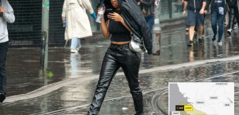
BRITS face battling floods and downpours for two days with up to three inches of rain falling in hours today.
The Met Office has issued a yellow weather warning for today from 3pm which lasts until midday on Saturday.


The warning covers most of Kent and Surrey in south-east England.
Spray from the rain and flooding is expected to make driving conditions difficult and could see some roads being closed.
There is also a chance of train and bus services either being delayed or cancelled in the flooded areas.
The warning added there was a small chance that homes and businesses could be flooded, causing some buildings to be damaged.
Read More on the Weather

Brits to be hit with coldest day of the season with SNOW in icy polar plunge

Showers to hit as heatwave cools – but 35C scorcher just days away
Currently, the UK is trying to recover from the joint hottest summer on record.
More than 400mm of rainfall is needed in southern England to reach the average amount of rain for the year, which would require the region to experience the wettest autumn ever.
So far, 2022 has been the driest since 1976.
It comes as many parts of the UK are set for a chilly weekend and temperatures in the northern parts of Scotland could fall below 0C as a “cold plunge” heads our way.
Most read in The Sun

Toney among five players left out by England as they face Italy in Nations League

Phil & Holly 'heckled by crowd for skipping queue to see Queen's coffin'

RuPaul's Drag Race star Cherry Valentine dies at 28, heartbroken family reveal

Harry snubbed dinner with Charles & Wills after Meghan banned from joining family
Those more remote parts could see some snowfall on higher ground although it is not expected to cause any disruption.
Other parts of the UK could see night time temperatures down to single figures.
Eastern parts are likely to see some showers although at the start of the weekend things should be drier and brighter and a band of high pressure comes in from the West but it will still be cold due to a north-westerly air flow coming in.
Low pressure on Sunday could bring a risk of gales and heavy rain for the northern part of Scotland.
For most though Sunday will remain dry and bright.
The unsettled weather is forecast to continue into the early part of next week.
Met Office forecaster Aidan McGivern said: “Across the UK temperatures are going to be below average for the second half of the weekend and into Monday as well as Tuesday.”
He said it would be “most likely the coldest air of the season so far.”
Read More on The Sun

I work in Wetherspoons and here are the pub’s secrets… including ‘frozen’ fry ups

I accidentally named my twins after TV characters – I’m so embarrassed
Mr McGivern added: “It’s certainly going to feel cold first thing with a touch of frost in the North and chilly winds.”
Tuesday is forecast to be the coldest of the season so far as the unsettled weather continues although temperatures are then expected to pick up as the week progresses.

Source: Read Full Article