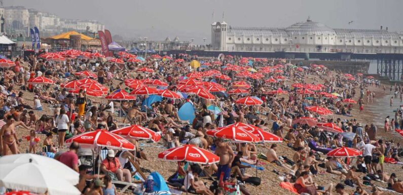
A HEATWAVE has been declared in 13 areas across the UK – with Brits bracing for 33C temperatures today.
The hot weather comes after heavy rain and wind battered the country for much of the summer.


Areas in West Yorkshire, Cornwall, Devon and Wales are currently facing a heatwave – with many more areas set to join the list, the Met Office say.
In the South of England, temperatures are expected to hit 30C, while London is gearing up to hit a high of 32C at around 4pm Thursday.
Temperatures reached 32C in Kew Gardens, London on Wednesday.
And some areas could be even warmer today, with highs of 33C expected.
Met Office meteorologist Amy Bokota said: “In total there’s 13 stations that have officially marked it [a heatwave].
“As you go through the next couple of days quite a few extra will be added onto that.
"33C is expected perhaps on Thursday, which is expected to be the peak.
“It will then be 32C right the way until Sunday for some places in the South."
Most read in The Sun
 baby panic
Kourtney reveals terrifying details of hospital dash for surgery to save baby
 TERRY’S AL GOLD
John Terry to join Saudi Pro League as he makes managerial breakthrough
 FAMILY FEUD
Jade’s mum brands Jeff Brazier a ‘c**k’ after sneaking in to see Bobby win NTA
 BRUTAL ATTACK
Woman dies after two Rottweiler dogs savaged her when she tried to pet them
Warm weather is only dubbed a heatwave when daily maximum temperatures meet – or exceed – a local area's "threshold" for three days or more, the forecaster says.
The heatwave temperature threshold differs from region to region.
In Scotland and the North of England, the threshold is 25C, while most of the Midlands and Birmingham it's 26C.
London and the South East have the highest threshold at 28C.
Heatwaves are often caused by a jet stream north of the UK.
The heatwave is being driven by tropical storms pushing a high pressure system over the UK, with the jet stream having moved to the north and bending into what is known as an omega blocking pattern.
Named after the Greek letter omega because of its shape, this system occurs when an area of high pressure gets stuck between two areas of low-pressure to the west and east and also slightly south.
This has brought torrential rain and flooding for Spain and Greece but hot, dry and clear conditions for the UK and central Europe.
Met Office Chief Meteorologist Paul Gundersen said: “High pressure is situated to the southeast of the UK, which is bringing more settled conditions and temperatures well above average for the time of year.
“While the highest temperatures are expected in the south, heatwave conditions are likely across much of England and Wales especially, with parts of Scotland and Northern Ireland also likely to see some unseasonably high temperatures.
Read More on The Sun

Jack Whitehall shares first snap of newborn in hospital with Roxy Horner

Mum’s heartbreaking warning after twin girls, 4, suffocate to death inside toy box
“An active tropical cyclone season in the North Atlantic has helped to amplify the pattern across the North Atlantic, pushing the jet stream well to the north of the UK, allowing some very warm air to be drawn north.
“It’s a marked contrast to the much of meteorological summer, when the UK was on the northern side of the jet stream with cooler air and more unsettled weather.”


Source: Read Full Article